ESA SEN4LDN kicked off
Sentinel high resolution data to improve Land Degradation Neutrality monitoring
Today we officially kick off SEN4LDN, a new European Space Agency (ESA) project to address the need for higher spatial resolution datasets to monitor Land Degradation Neutrality (LDN). The SEN4LDN consortium aims to develop, demonstrate and validate robust and automated EO methods to map land cover changes and land productivity dynamics that exploit the high frequency and spatial resolution of Sentinel-1 and 2.
Land degradation affects the livelihoods of millions of people worldwide. Diminished overall productivity and reduced resilience in the face of climate and environmental change, have made addressing land degradation a global priority formalized by the United Nations Convention to Combat Desertification (UNCCD) and the Sustainable Development Goals (SDGs), in particular Target SDG 15.3 on Land Degradation Neutrality (LDN). The SDG indicator 15.3.1 is the key measurement to monitor country progresses on SDG target 15.3, and is expressed as the spatial extent of degraded land. Current monitoring focuses primarily on the use of 3 sub-indicators (land cover changes; trends in land productivity/functioning; and trends in carbon stocks above and below ground) using global datasets at a resolution between 250 m and 8 km. However, these datasets are often considered too coarse in many areas in order to accurately assess the complexities of degradation processes.
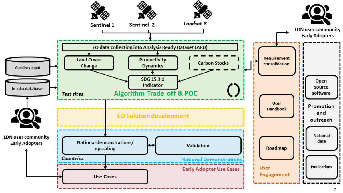
Conceptual overview of the SEN4LDN project. Throughout the project user engagement will be key in the project.
SEN4LDN targets to increase the spatial details of national assessments of land degradation and restoration, and provide synoptic information for countries to plan LDN interventions at appropriate scale. Within VITO Remote Sensing, we will mainly focus on the development of robust mapping of land cover changes and the integration of the different sub-indicators into an open source and operational workflow to monitor SDG indicator 15.3.1 at high resolution. ESA's SEN4LDN project will run over a course of 2 years until October 2024.
SEN4LDN is led by VITO Remote Sensing (Belgium) in cooperation with Lund University (Sweden), GFZ (Germany), Wageningen University (The Netherlands) and Conservation International (USA).
