VITO and River Cleanup kick off the Waste Watchers project
We’re proud to announce that ‘Waste Watchers’ has been selected as one of the 5 citizen science projects of the amai! programme. The amai! programme, organized by Scivil, Knowledge Centre Data & Society (Kenniscentrum Data & Maatschappij), and the Flemish Department of Economy, Science, and Innovation (EWI), aims to increase the involvement of citizens in the use of Artificial Intelligence (AI) to answer societal problems. The Waste Watchers project, coordinated by VITO Remote Sensing and River Cleanup, will enable citizens to easily map riverbank litter using drones. With these aerial images an AI system can be trained to automatically recognize litter. This will allow organizations to optimize clean-up interventions and thus structurally tackle litter in Flanders.
Enabling citizen scientists to map riverbank litter using drones
The amount of street litter keeps on increasing every year, and currently represents 3.5 kg per person per year in Flanders. Next to increasing mitigation costs, much of this litter risks ending up in the rivers and seas, from where it threatens the food chain. Therefore, preventing the litter from ending up in rivers is crucial. Litter maps would be very helpful in optimizing the limited clean up resources and interventions, but these are hard to obtain based on sparse ground observations alone.
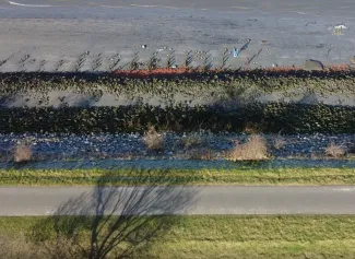
That’s why Waste Watchers wants to tackle this from a bird’s eye view, using drone imagery. However, if we want to achieve a wide coverage at a sufficient resolution without the complexity and cost of deploying very advanced systems, we must use many hands to make light work. Therefore, the Waste Watchers project aims to enable citizens to use small consumer drones to collect as much data of the riverbank litter as possible.
Within the project, we will offer the necessary tools to collect drone data in a safe, responsible, and standardized manner. Waste Watchers will provide an automatically generated flight plan for the desired area and the possibility to easily upload the collected drone data. The data are then processed using artificial intelligence to detect, localize and quantify street litter.
Many drones can make light work in mapping environmental threats. This project is a unique opportunity to put remote sensing technology right into the hands of the broad public and create awareness from an entirely new perspective.
Klaas Pauly - Project Manager Waste Watchers, VITO Remote Sensing
Artificial Intelligence to automatically recognize litter
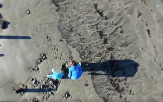
Waste Watchers aims to map up to 100 km of riverbanks along the Scheldt. Citizens who already own a drone will be encouraged to collect as much data as possible of the Riverbanks along the Scheldt. For the people that don’t have a drone of their own but are eager to participate in this citizen science project, Waste Watchers will organize five road shows. During these events people will be able to use a drone and experience the technology hands-on. Citizens will also be involved in the labelling of imagery to train AI models and the validation of the results on the terrain. Eventually, the obtained results will guide clean up efforts on World Cleanup Day in September 2023.
Waste Watchers started in January 2023 and will run for 1 year. After internal developments and validations, Waste Watchers will launch a public campaign to encourage citizens to participate and collect as much data as possible during the summer of 2023. By the end of the project, we will publish extensive documentation on how to scale up this system, and we will contact potential stakeholders to establish a continued exploitation. Please visit the project website (in Dutch) to stay informed about the public campaign and how to participate.