WaterMonitor
The WaterMonitor is a user-friendly platform to monitor Chlorophyll-a in our Flemish water bodies. WaterMonitor is developed for the Flanders Environment Agency (VMM) in collaboration with the EODaS programme (Earth Observation Data Science) of the Flanders Information Agency, and NAZKA Mapps.
Monitoring Chlorophyll-A in Our Water Bodies
The Flanders Environment Agency (VMM) has a wide range of responsibilities in the domains of water, air, and environment (e.g. climate adaptation). The Water Monitor Department of VMM has, among other tasks, the task of measuring, modelling, and reporting surface water quality and water soil quality. In support of the European Water Framework Directive, the quality element phytoplankton is reported by VMM on the basis of Chlorophyll-a concentrations in relevant water bodies. Chlorophyll-a concentration is currently measured in 100 rivers and 16 lakes.
Water Quality Monitoring From Space Made Easy
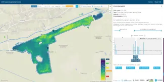
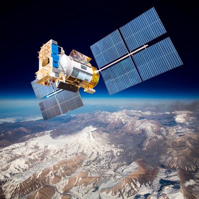
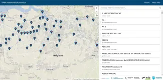
To support VMM with this task, our remote sensing experts in water quality monitoring use free Copernicus Sentinel-2 satellite images and remote sensing technology to produce time series of Chlorophyll-a maps. These Chlorophyll-a products are provided to VMM via the online WaterMonitor platform developed by NAZKA Mapps. The WaterMonitor allows VMM to easily search, navigate, and monitor Chlorophyll-a temporally and spatially for Flemish water bodies.
The WaterMonitor retrieves its information from the Sentinel-2 satellites, which pass by every 5 days. Chlorophyll-a content is derived from the satellite images. Unless clouds obscure the satellite view, VMM can access Chlorophyll-a maps of most of our inland water bodies every 5 days within 24 hours after Sentinel-2 image acquisition.