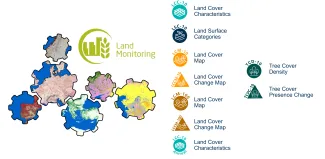
Copernicus LCFM Service
The Copernicus LCFM will implement a service to continue and enhance the 100m Copernicus Global Land Cover layers and provide a dynamic global land cover and tree cover density service at 10m resolution for the years 2020-2026.

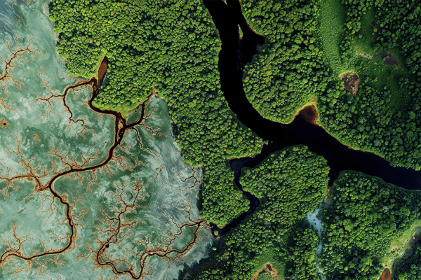
Insights into the state of our land cover and tropical forests
The Copernicus Global Land Cover and Tropical Forest Mapping and Monitoring Service (LCFM) aims to provide valuable data and insights into the state of global land cover and tropical forest ecosystems. Copernicus LCFM will implement a service to create land cover maps and tropical forest monitoring products at 10 m resolution for the years 2020-2026.
The Copernicus LCFM service is part of the global component of the Copernicus Land Monitoring Service. Copernicus LCFM will not only continue the time series of the 100 m Copernicus Global Land Cover layers but also enhance the existing service by providing a high resolution (10 m) dynamic global land cover service.
Following on the Copernicus Global Land Cover maps and ESA WorldCover
The Copernicus LCFM service is a framework contract under the authority of the Joint Research Centre (JRC) of the European Commission. Ever since the release of the 100 m Copernicus Global Land Cover maps and the ESA WorldCover products, which raised the bar significantly in spatial resolution and coverage, there has been an enormous interest for an operational service that can provide high-quality global land cover products. Additionally, the EU Deforestation-Free Regulation (EUDR) and the REDD+ Policy process need reliable, timely and consistent tree cover information.
Towards a full-scale production of annual and sub-annual land cover and forest monitoring products
The Copernicus LCFM project officially kicked off in January 2024 with a ten-month ramp-up phase to test and refine the workflow on a subset covering about 10% of the total land surface. After this phase, the team will start with the full-scale production of the annual and sub-annual land cover and forest monitoring products for the year 2020. The initial public results are expected to be available early 2025. Subsequently, the service will be extended to produce the 2021-2026 products.
The Copernicus LCFM service is being implemented by a consortium of leading organizations in the field of remote sensing and environmental monitoring, including VITO (lead), GeoVille, GFZ, IGN FI, IIASA along with support from two sub-contractors, i.e., Sinergise and Telespazio Ibérica.

Consortium:
- VITO Remote Sensing: serves as the overall consortium lead, with responsibilities encompassing the coordination, management, and successful implementation of the consortium's activities and objectives. VITO is entrusted with overseeing the Global Land Cover Activities, including algorithm design, implementation, and global production
- GAF AG: is responsible for overseeing the Tropical Forest Cover Activities, specifically focusing on algorithm design and production for a pan-tropical TCD product and annual Tree Cover Presence Change products
- GeoVille: handles the implementation of Quality Assurance and Quality Control procedures for the various input and output products. Additionally, they facilitate harmonization activities with CLC+ Backbone and GHSL
- GFZ: coordinate the user engagement activities for the purpose of the services and datasets to be delivered here, i.e. consolidate available user requirements and complement with new activities
- IGN FI: coordinate the product validation activities, i.e. setting up a scientifically sound and fit for purpose validation and assess the output products during production to assess and confirm that these product meets the desired requirements, specifications, and user expectations
- IIASA: takes charge of collecting, curating, homogenizing, and ensuring the quality of the training data. These inputs will be utilized for the global land cover activities
Subcontractors:
- Sinergise: provides support for implementing the production on the targeted cloud environment, specifically the Copernicus Data Space Ecosystem. Additionally, they set up an internal viewer service to inspect intermediate and final products
- Telespazio Ibérica: takes charge of collecting and curating the training data for the forest cover activities