Surface albedo and emissivity for Belgian cities (SuaBe)
The SuaBe initiative is an exploration project funded by the BELSPO STEREO-IV programme, which focuses on designing and implementing a fast and robust algorithm that enables us to invert remote sensing images of cities and get 3D models to simulate urban albedo and emissivity maps.
Surface albedo and emissivity for Belgian cities
Why SuaBe?
The large abundance of materials absorbing short-wave radiation from the sun and the concentration of people make cities particularly vulnerable to the heat island effect.
Although the surface albedo and emissivity of the materials in the urban fabric are key quantitative properties for heat pollution mitigation strategies, these are often lacking citywide. Observing cities from space with high-spatial resolution optical and thermal-infrared sensors can circumvent the in-situ stations' spatial and temporal coverage limitations.
However, the measurements from space correspond to information relative to a limited number of satellite acquisition geometry and a limited number of spectral bands, which prevents the accurate computation of needed quantities such as urban albedo maps. In order to extrapolate satellite observations to any upward directions and to the whole spectral domain of interest, a physical model considering the urban complex 3D urban is needed.
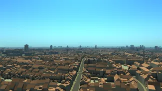
Fig. 1 DART simulation of the Brussels Urban Database, under a clear sky
The SuaBe initiative is an exploration project funded by the BELSPO STERIO-IV programme, which focuses on designing and implementing a fast and robust algorithm, that uses the 3D radiative transfer code DART to invert remote sensing images of cities as a 3D distribution of optical properties and temperature, using a geometric urban database.
This approach enables us to get a 3D model of the city that enables us to simulate urban albedo and emissivity maps at any date as long as the optical properties of urban elements remain constant. These optical properties can be updated with the inversion of a new satellite image.
Preliminary results
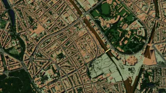
Fig. 2 DART Nadir simulation of a district of Brussels, with trees, before retrieval of real optical properties.
We've assembled a 3D urban geometric database, including the presence of vegetation and trees, see fig. 2.
Preliminary results are displayed in fig. 3, for short-waves. The left panel of fig. 3 shows a RGB composite of Sentinel-2 observations at 10m spatial resolution of Brussels. The right panel of fig. 3, displays the DART simulation with calibrated optical properties obtained via the SuaBe inversion algorithm.

Fig. 3 Brussels 10m images using RGB false color composition.
Left: Sentinel-2 image
Right: DART simulated image using optical properties from final inversion