Drone-based detection of oil spills in a port environment
A dedicated workflow to detect oil spill in a port environment
Under the authority of the Belgian Science Policy Office (BELSPO) the Port of Antwerp-Bruges, the University of Antwerp and VITO Remote Sensing will develop a workflow for oil spill detection by using drone imagery. The workflow should be able to detect, delineate and provide coordinates of an oil spill in an early stage. The technology will be demonstrated under real circumstances in the Port of Antwerp-Bruges.
When an oil spill is detected in a port, the clean-up often requires closing off part of docks which has an impact on the logistic flow. The earlier the spill is detected, the less impact it has on the environment and the faster the port can be fully operational again. In this new project we will develop a new workflow for oil spill detection in a port environment by using drones.
So far, oil spill detection in marine environment has been mainly based on SAR and optical satellite data, and validated on recent calamities. These spills are often dispersed over a large area and are persistent over a long time. The circumstances in a port are completely different. By using drone imagery, we can offer a flexible and mobile solution with the right pixel resolution and image footprint to support oil spill detection in a port environment. We can use new cameras sensitive to specific wavelengths for the oil types envisaged and detect an oil spill as early as possible after the start of the leakage into the water. This not only reduces the potential effects on humans or the environment, but it gives the opportunity to the port authority to improve their monitoring efforts and define the cause.
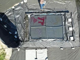
First outside test with a UAV flying above a small-scale set-up for testing camera performance on different oil types.
Shifting from a satellite-based to a UAV-based solution may seem straightforward but it requires a different setup and image processing workflow. As data acquisition is done with low cost UAV platforms and different cameras, we need to define protocols for camera set-up, settings and flight execution, and develop an appropriate operational workflow to process and fuse the data in order to obtain the best data quality possible.
Within the project, VITO will work on the camera integration under the UAV platform, the operational flight procedures, develop a dedicated image processing workflow together with the University of Antwerp and help conducting the in situ field demonstrations in the Port of Antwerp-Bruges. VITO already has years of experience in drone-based image processing by developing MAPEO water. The challenge here is to keep in mind the environmental settings between a port environment are different compared to the open ocean such as relatively small water bodies (docks, locks, etc.), different circumstances (less current, waves and wind) and other oil types involved (often less viscous purified oils such as hydraulic oil or diesel).


